
 Welcome to the Millers River Watershed Council!
A Healthy Vision for our Watershed
MRWC has worked since 1970 to protect the health of the Millers River, its watershed, and the communities–human and non-human–for whom it is home. As part of that mission, we promote stewardship and recreation on the Millers River and its tributaries. MRWC welcomes your input.
Please join us to support healthy waters for healthy communities! You can use the Donation button (near the top right of this or any website page) to donate using your credit card or PayPal account. Thank you!
February 2026
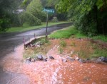
Gardner Sludge Landfill Expansion – Cancelled!!!
Huge thanks to everyone who supported MRWC, GCA and the Coalition!
See the SLF page for details!

Sue and Alan Rousseau, Gardner Clean Air coordinators, and MRWC director Ivan Ussach (holding newspaper), convened recently for a beer and a bite to celebrate this major victory!
September 2025:
Bacterial monitoring: Is it clean? MRWC’s first round of bacterial monitoring post-Covid was successful, made possible with support from the Connecticut River Conservancy (CRC). Volunteers collected samples at five sites throughout the watershed for analysis at the CRC’s lab in Greenfield. As in past years, results were generally “clean for swimming”–except during two rain events, when the Athol and Baldwinville sites scored “not clean.” (No surprise there: always wait 48 hours before swimming after a rain event.) We hope to add more sites in 2026!
June 2025:

Listening Session – Impacts of flooding on elders: Friday, June 27th @ 3 pm at MREC
As I sit here on Saturday afternoon the rain continues to fall. Basements are flooding, culverts have been failing and, needless to say, flooding is once again a popular topic. So the timing is opportune to announce a “listening session” on flooding for the Millers River watershed community, scheduled for Friday, June 27th from 3-4:30 pm at the Millers River Environmental Center in Athol at 100 Main St. The focus of this event is to hear from senior/elder residents of our watershed towns how they have been affected by flooding in recent years. The building is wheelchair-accessible and refreshments will be served.
Big storms and flooding are expected to increase in both frequency and intensity as the climate continues to warm and become less stable. The listening session will inform strategies being developed by regional planning agencies in the Connecticut River watershed to assist and support seniors in dealing with the hazards associated with flooding. We want to hear directly from elders on how you/ they have been affected by flooding–anywhere in the Millers River watershed or surrounding towns. Please email council@millersriver.net to register for the event.Volunteer bacterial water quality monitoring (E. coli) returns to the Millers!
MRWC is pleased to announce that we will once again conduct volunteer water quality monitoring in the watershed this summer, with the support of the Connecticut River Conservancy and their lab. Sampling commences on Wednesday June 18th and will be bi-weekly through August 13th. Please contact MRWC if you are interested in volunteering to collect samples–a brief training is required. We will be sampling at the following five core locations: * Otter River at Baldwinville (Templeton) * Millers River at Cass Meadow (Athol) * Millers River at Orange Riverfront Park (Orange) * Millers River at Erving Center * Millers River at Confluence with CT River.
Certificate issued on Gardner Sludge Landfill’s Draft Environmental Impact Report (DEIR) – a “mixed bag:
The EOEEA Secretary’s determination, issued on May 20th, is that the DEIR “adequately and properly complies with MEPA and its implementing regulations.” However, Secretary Tepper rejected the City’s Preferred Alternative to build out the expansion all at once, instead requiring a “phased” construction. This is very good news, as it will allow for a flexible approach to future options and decision-making. Plus, the City has to respond to the comments made by the Secretary, MassDEP and others–including over 60 public comments from organizations and individuals–in a Final Environmental Impact Report (FEIR). Thanks to those of you who submitted comments! The Secretary also reserved the right to require additional MEPA review. The SLF’s DEIR Certificate can be downloaded from this link: MEPA Environmental Monitor.
Templeton residents vote to prohibit “plastics recycling”:
At their May 14th Annual Town Meeting, Templeton residents voted overwhelmingly to approve zoning amendments prohibiting the commercial production of fuels made from plastics and other materials. The vote makes permanent a Moratorium on such activities passed unanimously at their special Town Meeting on December 6th, 2024—-pending review by the state’s Attorney General. Templeton Community Against Toxic Waste, a local group, has played an instrumental role in organizing residents, in response to proposed plans to build a large-scale industrial “plastics recycling” facility utilizing incineration, on the contaminated property of a federal Superfund site; see more at: templetoncommunityagainsttoxics.org
2024 Highlights
This year, on top of the continuing saga of the proposed sludge landfill (SLF) expansion in Gardner, for which a Draft Environmental Impact Statement (DEIS) mandated by the head of the state’s Executive Office of Energy and Environmental Affairs is expected soon (early in the new year), MRWC has been grappling with a number of other serious development threats in the watershed. And: Thanks to serious grassroots organizing and opposition, there have been some successes, which MRWC contributed to!
In Templeton, a year-long campaign by the newly formed Templeton Citizens Against Toxic Waste against the proposed siting of a so-called “plastics recycling” facility on a former EPA Superfund site led to a unanimous vote earlier this month by town residents at a special town meeting to place a moratorium on plastics incineration; voters also made changes to the Solid Waste Bylaw to protect public health against burning tires or plastics.
Another year-long battle in Wendell by a broad coalition, led by No Assault and Batteries, resulted in the withdrawal of a proposed 100 MW Battery Energy Storage System (BESS) to be located over an aquifer in pristine forestland. In Winchendon, MRWC is investigating the dumping of contaminated roadway debris materials in a quarry site bordering the Millers River.
One outcome of the BESS campaign has been a realization of the need to protect community interests during the siting of large energy projects supported by the State’s plans for achieving its long-term climate and energy goals. As a result, MRWC has been working with several citizens groups representing Millers River Watershed towns to explore the potential of decentralized/distributed energy systems to meet local energy and climate protection needs, towards which we have participated in public educational forums at the Millers River Environmental Center and the Garlic & Arts Festival.
We’ve also made some initial strides on our Stormwater Initiative: MRWC is serving on the Town of Athol’s Lake Ellis Watershed Management Committee, to reduce stormwater-related impacts to the Lake, and we have plans for town-wide stormwater education; we also plan to resume our participation in the Connecticut River Conservancy’s bacterial monitoring program in 2025 after a hiatus of several years, in light of bacterial loading’s impact on local waterways. And MRWC continues to serve on the Brownfields Redevelopment Advisory Committee implemented by the Montachusett Regional Planning Commission, as well as a newly formed Athol Brownfields Redevelopment Committee.
New lawn signs – See Landfill page to order while supplies last.

Current 2024 priorities:
Large-scale Battery Energy Storage System proposed for Wendell — And: the challenge of siting large energy projects in our towns
On March 27th, a Community Forum on the Wendell BESS project and the local challenges of siting large energy projects was held at the Millers River Environmental Center. Around 50 people from many towns in the region attended the event, which was sponsored by North Quabbin Energy, the Millers River Watershed Council and others. A Resource List for BESS, clean energy, project siting, and the MA Climate Plan was compiled as a handout and is available on the PROJECTS page of this website–along with contact information for participating in current and future campaign activities.
NQ Community Energy presentation/discussion – April 24 @7 pm (Zoom)
Please join us on Wednesday, April 24th at 7 pm for “Community Energy – Future Collaboration,” an online presentation and discussion with Aimee Hanson, chair of Athol’s Energy Committee and member of the town’s Planning Board. The event is being hosted by North Quabbin Energy and the Millers River Watershed Council. Registration is required – see below.
As a followup to the Community Energy Forum held March 27th at the Millers River Environmental Center, Aimee will share information about how Athol is managing the clean energy transition, including the town’s Decarbonization Plan and recent Zoning Development for Battery Energy Storage Systems (BESS). Come learn from one town’s experience and discuss energy issues with Aimee and residents of other local towns.
To register and receive the Zoom link, respond to this email by 5 pm on April 24th with “Register.”
- Stormwater Initiative
- Lake Ellis Watershed Management Partnership
- And of course:
Advocating for an alternative to the proposed Gardner Sludge Landfill Expansion!
MRWC is opposing this ill-conceived project, which will, if approved, have substantial negative consequences for our region and beyond. The area of the proposed project expansion is within 1,300 feet of the Otter River and contains several vernal pools certified by MRWC.
MRWC has been working for several years with residents of Gardner to urge the City to adopt a cleaner, safer and more economically sensible solution to managing its sludge waste. Besides the adverse impacts the project would cause on the local and regional environment, we believe that approval of this project would send the wrong message to communities and stakeholders state-wide about the future of wastewater solids management throughout the State. We don’t believe the Chair City’s legacy is to become Dump City for the rest of the Commonwealth.
In the link below you will find:
- Project Timeline: updated 1/28/24
- Project Map: 1-mile radius
- 2/10/23 – DEP ruling requiring that a Draft Environmental Impact Report (DEIR) must be submitted.
- October 2022 Coalition report.
- Victory for Vernal Pools in Gardner, March 2021
- Detailed project Information
- Environmental Justice statement, May 2022
Link
2020
Celebrate the new Norcross Hill Wildlife Management Area!
Join MassWildlife, the Department of Fish and Game, and other partners on October 9, 2019 to celebrate the creation of the new Norcross Hill Wildlife Management Area! Meet at 10 a.m. at 100 Norcross Hill Road off Route 68 in Templeton.
Norcross Hill Wildlife Management Area (WMA) in Templeton contains 465 acres of land that was previously owned by the Walter E. Fernald Corporation. WMAs are open to the public, and Norcross Hill is no exception. Visitors can enjoy the woodlands and wetlands as well as nearly a mile of frontage along Norcross Hill Brook and Beaver Brook. The variety of habitat within this property supports both game and non-game wildlife species. White-tailed deer, bear, waterfowl, and turkey can be found in the woods and fields. American bitterns and eastern whip-poor-wills—both protected by the Massachusetts Endangered Species Act— have also been observed in the area. In addition, the grasslands within the property are important for the conservation of bobolinks in New England.
This property, which was previously closed to hunting, provides new access for Massachusetts sportsmen and women. This acquisition also has significance on a regional scale. The Norcross WMA is now part of an assemblage of over 2,200 continuous acres of protected lands from Otter River State Forest to the Templeton State Forest. MassWildlife worked with the North County Land Trust and Mount Grace Land Conservation Trust to acquire the property. The partnership received a Landscape Partnership Program Grant from the Massachusetts Executive Office of Energy and Environmental Affairs. The Norcross Hill WMA is just 1 of over 40 land acquisition projects completed by MassWildlife in Fiscal Year (FY) 2019 (July 2018–June 2019). In FY 19, MassWildlife protected over 2,420 acres for wildlife to thrive and for people to enjoy!
Help prevent Tully Lake development
About 200 hundred acres of beautiful hillside (in Athol) across from Tully Lake (in Royalston) was at risk for becoming a solar field! This could have resulted in loss of homes for wildlife and definitely would have destroyed the stunning views that we have all enjoyed for generations.
The Athol Planning and Development Board approved and passed a proposal for the solar installation, but neighbors of this land are not backing down! They hired a lawyer and appealed this decision in court. Neighbors of the land and their legal team are fighting tirelessly to save this land and preserve this area, but they need your help!
By making a donation care of Millers River Watershed Council: online via PayPal/credit card: go to millerswatershed.org and click the orange “make a donation” button–then add note for “Tully Lake.” – or mail check to MRWC, 100 Main St., Athol, MA 01331–make check payable to MRWC and add note for “Tully Lake.”
You will be contributing to legal fees that would help prevent future development proposals on this land. Additional funds would go towards possible permanent conservation of this land. Please consider helping your fellow man, our environment, and wildlife by making a donation today, and encourage family and friends to do the same. Together, we can!
 Exploring A Local Gem:
The Millers River Watershed Council and North County Land Trust are co-sponsoring this series of guided hikes at the Cummings Conservation Area off Bridge Street in Gardner (hosted by the City of Gardner Conservation Commission). The first hike is Sept. 21, 2019 (focus on ecology and geology), followed by hikes on October 26th (focus on local industrial history) and November 23rd (focus on local railroad history). All hikes are from 2:30-4:30 pm, and meet at Bridge Street in Gardner, next to the Otter River. Special Instructions: Bring water, insect repellent, and walking or hiking shoes.
For more information: https://northcountylandtrust.org/events/a-local-gem/
BLUE TRAIL ALERT!
6/1/19 – Due to log jams caused by spring flows, the Upper Millers River Blue Trail (Winchendon to Birch Hill Dam) is not a recommended paddling area for novice paddlers. Experienced paddlers should still be prepared for portaging. MRWC will post updates as soon as conditions change.
______________________________________________
____________________________________________________
EPA issues final Small MS4 General Permit to control stormwater statewide.
Following a lawsuit by environmental groups, a long-awaited federal stormwater permit went into effect for MA on July 1. The permit requires municipalities–including Gardner, Winchendon, Templeton, Ashburnham and Westminster in the Millers River watershed–to do more to protect water bodies from polluted storm-water runoff, the state’s top water pollution problem.
“This is a major victory for water quality throughout the Commonwealth,” said Julia Blatt, Executive Director of the Massachusetts Rivers Alliance, which led the lawsuit that was joined by the Connecticut River Conservancy and many watershed groups from the eastern half of the state.
For more on the MS4 permit click here. For a link to town-level maps for MS4 communities in MA click here.
2019 ARM Results
https://wrrc.umass.edu/research/projects/acid-rain-monitoring-project/arm-2019-results
2018 Acid Rain Monitoring (ARM) Project results available
Results from the volunteer ARM project for pH and alkalinity are available here from 138 sites sampled across Massachusetts in April of this year. About a dozen Millers River watershed sites are included. Water bodies are listed alphabetically and the town is identified, so it’s easy to scroll through the list. ARM is run by UMass’ Water Resources Research Center: their results page includes a link to a searchable database extending back to 1983.
Chair City Profile (Gardner)
Gardner produces only a tiny fraction of the furniture it once did, but central Mass native Tracie Pouliot is helping to keep that vital history alive. Read about the Chair City Community Workshop she created in Gardner, where–with a Mass Humanities grant–she launched the Chair City Oral History Series, a collection of reminiscences collected from former employees of Nichols & Stone.
Just Released – MRPC Summary of Recent Brownfield Site Assessments:
 Site assessment work has included Phase I and Phase II Environmental Site Assessments (ESAs) and hazardous building materials surveys (HBMS), with the goal of establishing site environmental conditions before considering redevelopment or reuse. MRWC serves on MRPC’s Brownfields Advisory Group. To view summaries of the five sites located in the Millers River watershed (Winchendon, Gardner, Royalston, Ashburnham), click here.
2017 Annual Meeting: Highlights – Slide Show
For those of you who missed the 2017 Annual Meeting, or who’d like a closer look at MRWC’s activities, here’s director Ivan Ussach’s powerpoint presentation with the highlights from a very productive year. – Slide Show Link
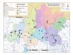 MRWC Monitoring Map – where we sample! Link
Since 2010, MRWC has monitored over 50 sites across the watershed. Is one near you? Take a look!
MRWC monitoring BUGS out!
Bugs Tell the Story! Aquatic insects are great indicators of stream health. Join a MRWC macro-invertebrate survey to collect these critters, sort them and then identify them.

Volunteers will work in teams to sample several streams in the central and eastern parts of the watershed, as this area is less studied.
So if you are OK with (or love!) bugs and maybe getting a bit wet, join us. To volunteer, contact watershed@millersriver.net

Adopt a Stream! MRWC volunteers are monitoring water temperature and pH along tributaries and streams across the watershed in 2018 View the watershed stream list to see all the streams in the watershed. For more info contact monitoring coordinator Keith Davies at watershed@millersriver.net.
Athol Wastewater Treatment Plant receives EPA award
The federal EPA has selected Athol’s Wastewater Treatment Plant for a 2016 Regional Wastewater Treatment Plant Excellence Award. The Athol WWTP was recognized by EPA’s New England Office for exceptional operations and maintenance. The plant was one of six facilities in New England acknowledged for exemplary performance during 2016. MRWC offers its congratulations and appreciation to the plant’s crew.
Support MRWC and support our waters!
2018 fundraising campaign underway!
MRWC continues to be ready for any movements on the withdrawn NED pipeline proposal, while we develop and promote several recreational Blue Trails across the watershed. We are also moving forward on water quality monitoring and working on economic revitalization projects as part of the MRPC’s Brownfields Advisory group… and more!
Please take a moment now to support this work as generously as you can. You can donate online via the website homepage (the upper right “MAKE A DONATION” button) –using PayPal or a credit card; or send a check to MRWC at 100 Main Street, Athol, MA 01331. THANK YOU!
Link to MRWC NED info page – HERE
NED pipeline project suspended! Opponents remain vigilant!

Become a Blue Trail steward!
Blue Trail happenings:
The map for the Upper Millers/Otter River Blue Trail is available. MRWC welcomes volunteers to help care for these trails.
Wish to help? Contact MRWC.

Rain Garden Pocket Guide available: published by the Massachusetts Watershed Coalition, this full-color guide is full of photos and illustrations that make building a rain garden simple, fun and affordable.
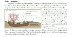
MRWC will provide a free copy of the Guide to watershed residents and businesses, while they last. Please contact MRWC to request a copy of the Guide. A modified pdf version of the Guide is also available for download. Contact us

Millers River Blue Trail Guide available. MRWC has released the official Millers River Blue Trail guide in (2) versions, a $3 waterproof edition and a complimentary non-waterproof version. A number of local retailers are carrying the waterproof guide while the complimentary copy can be found at the Athol & Orange public libraries.


